McPeek Land Surveying Mapping Zanesville Muskingum County Ohio

Defined Service Area

McPeek Land Surveying is professionally licensed in the state of Ohio. While we are able to meet all of your surveying and mapping needs we are restricted by drive time and have published residential rates which are noted below.

Our service area includes: Muskingum County, Guernsey County, Noble County, Morgan County, Perry County, Licking County, Coshocton County, Delaware County, Morrow County, Ashland County, Wayne County, Stark County, Holmes County, Tuscarwaras County, Jefferson County, Carroll County, Richland County, Adams County, Hocking County, Washington County, Monroe County, Baltimore County, Franklin County, Fairfield County, Knox County, Pickaway County and Harrison County.
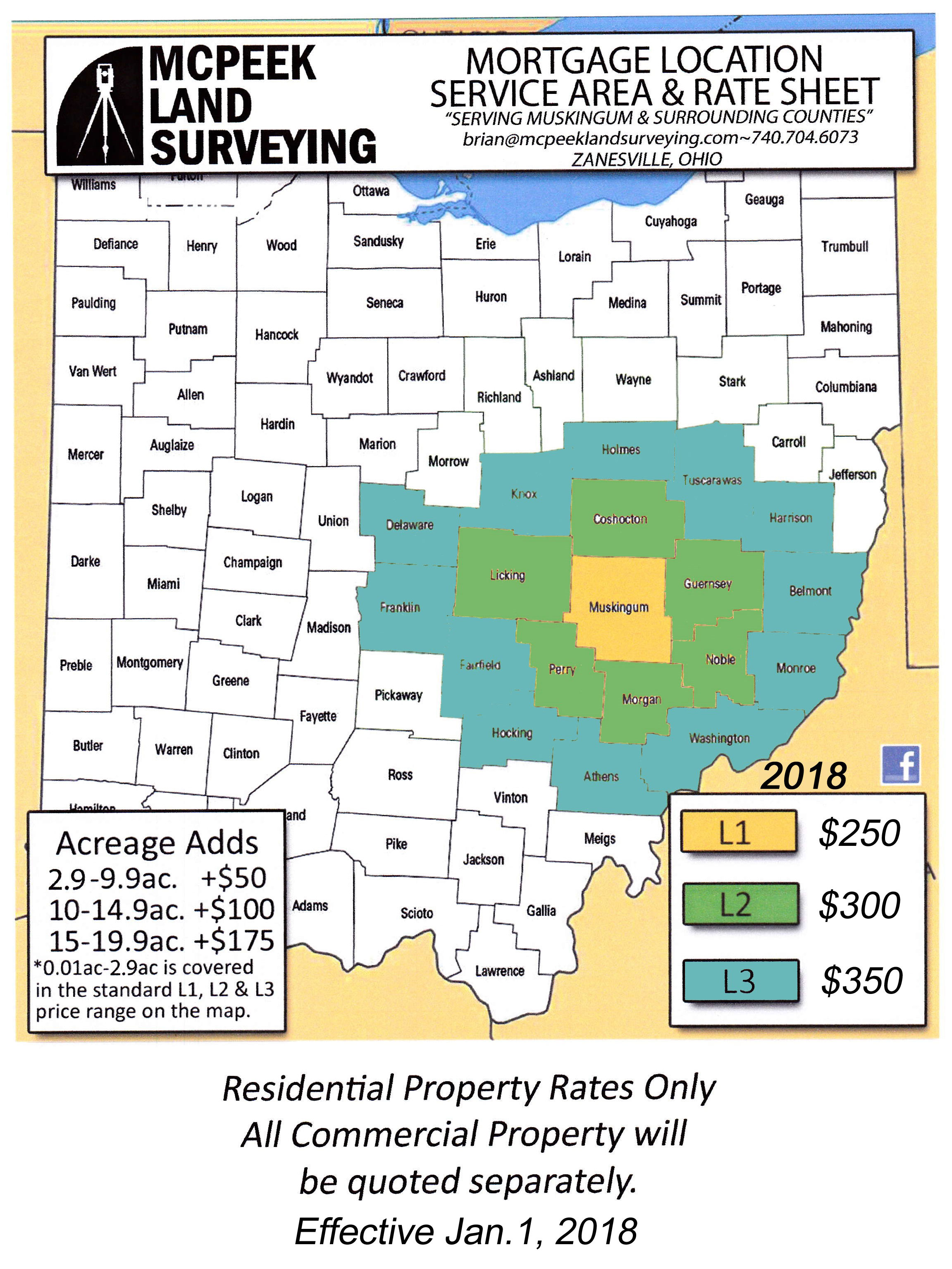
Professional Surveying Services


Ohio

Land Surveying Mapping Rate Sheet Territory

L1 Counties

  • Muskingum County

  • Licking County

  • Guernsey County

  • Noble County

  • Morgan County

  • Perry County

L2 Counties

  • Holmes County

  • Tuscarawas County

  • Harrison County

  • Belmont County

  • Monroe County

  • Washington County

  • Athens County

  • Hocking County

  • Fairfield County

  • Franklin County

  • Delaware County

  • Knox County

Ready for our services?

complete our order form

Order Service
Surveying Defined per the Ohio Administrative Code (OAC 4733-31-01)
4733-31-01 Surveying defined.
(A) Surveying shall mean any professional service performed for the purpose of determining land areas, the monumenting of property boundaries, the platting and layout of lands and sub-divisions thereof, including the topography, the alignment and the preliminary grades of streets, the preparation of: maps, record plats, field note records and property descriptions representing such surveys.
(B) The adequate performance of such work involves the application of special knowledge of the principles of mathematics, the related physical and applied sciences and the relevant requirements of law for adequate evidence to the act of measuring, and locating lines, angles, elevations, natural and man-made features in the air, on the surface of the earth, within underground workings, and on the beds of bodies of water.